PROJECT DETAILS
- Project Name: Mapping Urban Flood Vulnerability Using GIS-AHP and Its Implications for Climate-Resilient Sanitation: A Case Study of Barishal City Corporation
Overview
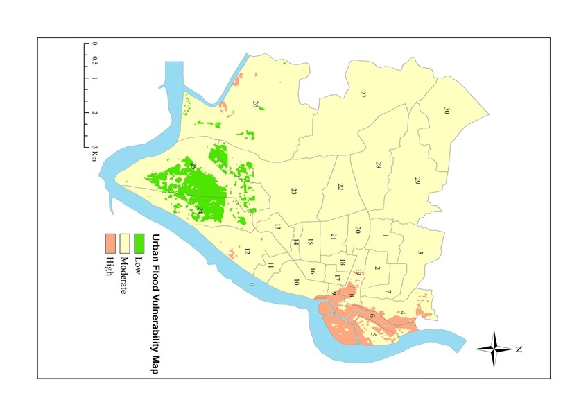
This research project examines urban flood vulnerability in Barishal City Corporation, Bangladesh, and recommends climate-resilient sanitation solutions to mitigate risks. Barishal is a coastal city with flat topography and high rainfall variability and faces increasing flood challenges due to rapid urbanization and climate change. The study emphasizes that when sanitation infrastructure fails during floods, with toilets becoming inundated, inaccessible, or collapsed, households may revert to unsafe practices like open defecation, exacerbating public health and environmental problems. This study integrated Geographic Information Systems (GIS) and the Analytical Hierarchy Process (AHP) to create a flood vulnerability map and translate it into practical sanitation recommendations.
The methodology involved analyzing seven spatial parameters: elevation, slope, average annual rainfall, land use/land cover (LULC), distance from river, distance from canals, and drainage density. Using pairwise comparisons based on expert judgment, it was determined that average annual rainfall (31%) was the most influential factor, followed by proximity to canals (22%) and proximity to the Kirtankhola River (18%). The study incorporated multiple data sources, including SRTM elevation data, PERSIANN-CCS satellite precipitation data, Landsat 8 imagery for LULC classification, and river/canal networks extracted from digital elevation models. The resulting vulnerability map classified Barishal into three zones: highly vulnerable (5.3% of the area), moderately vulnerable (approximately 90%), and low vulnerability areas, with highly vulnerable zones concentrated in the densely populated wards 5, 6, 8, and 9.
The study also found that the current sanitation system in Barishal relies almost entirely on on-site systems, with pit latrines comprising 54% and septic tanks 43.8% of households. Given this homogeneous sanitation infrastructure and the corresponding variation in flood exposure across the city, the team proposed location-specific interventions. By connecting flood vulnerability mapping directly to sanitation technology selection, this study bridges planning and implementation, enabling Barishal City Corporation to strengthen its sanitation system against the intensifying impacts of climate change.
This study was a collaboration between CSIRS-UIU and SKS Foundation (FANSA Bangladesh secretariat).